
Crossing Gregory National Park: Six Days of Remote 4WD Touring in the NT
Updated: Sep 12
Right up in the far north-west corner of the Northern Territory sits one of the most remote and rugged national parks in the country. Judbarra / Gregory is a maze of old stock routes and station tracks, hemmed-in river crossings and jump-ups, a long way from anyone. It had been on the bucket list since Karleah lived in Darwin nearly ten years ago, so when the timing lined up we pointed both rigs at it and set aside six days to cross it top to bottom. If you're into proper remote 4WD touring, there aren't many places left that touch it.

Here's how the crossing went, north to south, from Bullita down to the Buntine Highway. And if you're interested in following our tracks, you can find all the routes and waypoints in our GPX file pack.
Into the park: Bullita Homestead
We came in from the north, turning off just past Timber Creek, and made Bullita Homestead by evening. With ninety-odd kilometres of stock route waiting for us in the morning, we turned in early. Bullita is the jumping-off point for the Bullita Stock Route, and it pays to start it fresh.
The East Baines crossing and the Bullita Stock Route
First job of the day was getting across the East Baines River. It was still carrying a bit of water, so before anyone drove in we set up the recovery gear. You can't walk these crossings to check them the way you normally would, because there are saltwater crocs in these waterways, so the plan was to keep time in the water to a minimum. Snatch strap out and ready, one of us across at a time, and if anyone hung up on a rock the other could pull them straight out from the bank.
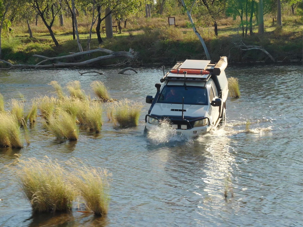
This is exactly why we run two vehicles on tracks like this. We don't tackle country this remote all that often, but a second rig gives you the confidence to, the same reason people convoy up on the Gibb, the Simpson or Cape York. That, and we'd both rather be driving than sitting in the passenger seat all week.
The stock route weaves through rocky, rugged country, following the river. The track is strictly one-way because some of the crossings are so narrow, and there's a jump-up near Spring Creek Yard that can only be driven in one direction, so it's worth having the route sorted before you set off.
We pulled into Spring Creek Yard for a look. It's a small camp, rated for about twelve swags rather than twelve vehicles, and the water there is the clearest we'd seen in a long time. Little waterfall, a turtle sunning itself, the lot. Genuinely tropical, and genuinely off-limits for a swim thanks to the crocs. A shame to walk away from, but we weren't camping there, so we soaked it in for a bit and pushed on.

We made Drovers Rest for the night. All up we'd covered about fifty kilometres in a full day's driving, which tells you the pace this country sets.
Limestone Gorge and the Calcite Flow
With one full day behind us and only fifty kilometres on the board, we didn't muck about the next morning. A quick detour towards Limestone Gorge, which was closed at the time after wet-season damage, but the Calcite Flow walk just before it was open and well worth the stop. It's a short one, about six hundred metres return and a bit of a climb, but the payoff is a strange, rippling limestone landscape sculpted by acid rain into sharp edges and frozen-looking flows. Looks like a waterfall that stopped mid-pour. Eerie, and one of the more unusual things you'll see in the park.

From there we had lunch and kept tracking south onto the Humbert Track.
The Humbert Track: Fig Tree Yard and Fig Tree Valley
Fig Tree Yard is a basic bush camp, a big fire pit and not much else. We've seen the odd review having a go at the camps in here, but honestly, you're a long way from anywhere, so nobody should be expecting flushing toilets and hot showers.
The next morning we headed out to Fig Tree Valley Lookout, expecting a walking track, and it turned out we could drive the whole way. A tight little pinch at the end, nothing serious, and then it opens up onto a cracking spot with big views. You'd have no idea it was up there from the track below. Worth the detour if you've got the time.

Then more crossings. One in particular had a nasty off-camber climb on the exit and enough murk that you couldn't read the depth going in. A rear diff lock that decided not to engage on the 79 series which made it more interesting than it needed to be, but a bit of momentum sorted it.

We had a quick look at Policeman's Hole on the way through before rolling into Top Humbert.
Top Humbert and Gunbunbu Waterhole
We reached Top Humbert Campground early, around two in the afternoon, but with roughly sixty kilometres to the next camp we'd have been arriving in the dark, so we called it there. Good decision. It's a nice cleared spot, and the grass was down enough that we could actually get to the water this time. Gunbunbu Waterhole is a beauty, deep and clear, signposted by a marker sitting randomly out in the scrub with no arrows to it. Clear enough water that you can see a fair way in, which is about the only croc-safety strategy that counts out here: just be with someone slower than you.

The Wickham Track and that descent
Leaving Top Humbert, the country got hilly, which made for a really fun drive. We passed the Wickham Track high point, a touch over 260 metres elevation, and pulled up at a plateau edge with 270-degree views across a massive valley. From up top you could see the descent dropping straight off the edge.

The first part of the descent is easy enough, then it gets into steep, rutted going, all wombat holes and loose stuff, picking your way down slowly. It looked a lot worse from the top than it drove, which is usually the way. A genuinely good bit of track.

Fish Hole Yard: an oasis outside the boundary
At the bottom we rolled up to what we thought was the Wickham River crossing, which turned out to be Fish Hole Creek. We'd crossed the boundary onto station country by then, but the signage still has Fish Hole Yard marked as a designated camping area, so we pulled up on the cleared western side of the creek.

This one's a proper oasis. Pristine water, big paperbarks lining the bank, cool down by the creek and only fifty-odd metres from camp. We grabbed the chairs and some snacks and spent the afternoon down by the water. If there's a highlight camp on this crossing, it's this one.
Closed again, and out to the Buntine
The last day carried the least certainty. We were hoping to link Fish Hole Yard through to Yarralin on the continuation of the Humbert Track. It shows on Hema with a road name, but it's not on the national park maps, so we had plans B and C in the back pocket. Five minutes up the road we had our answer: a sign reading CLOSED. Off to plan B, the Gibby Track down to intersect the Buntine Highway.

We knew going in that a couple of tracks might still be shut this early in the season, so it wasn't a surprise so much as a reason to come back. We aired up on the bitumen with one leg done and the next already pulling at us.
Six days across Gregory
All up, it took us six days to cross Gregory from top to bottom. We came in from the north at Bullita, ran the Bullita Stock Route and its East Baines River crossing, then worked our way south along the Humbert and Wickham Tracks down to the Buntine Highway. In between we camped at Spring Creek Yard, Drovers Rest, Fig Tree Yard, Top Humbert and Fish Hole Yard, walked the Calcite Flow out at Limestone Gorge, spent an afternoon at Gunbunbu Waterhole, and picked our way down the steep Wickham descent. A couple of tracks were still closed after the wet, which is reason enough to come back and finish what we started.
Gregory is remote, seasonal country. Tracks open and close with the wet, and a couple were still shut when we came through in mid-June, so check current conditions and closures with NT Parks before you head in, carry proper recovery gear, and don't rely on a single navigation source out there.
Watch the full episode
The whole crossing, start to finish.
Get the GPX pack
Want to drive it yourself? We've mapped the exact route into a GPX pack, the full north-to-south traverse plus every campground waypoint, ready to load into your navigation app.
Download the free location guide
We've also put together a free one-page location guide for Gregory: the best season, access, permits and fees, fuel and supplies, mobile signal, camps and the kit you'll want to carry.
Karleah & Paul, Adventure Lifestyle


Comments